
Overview
Claim size
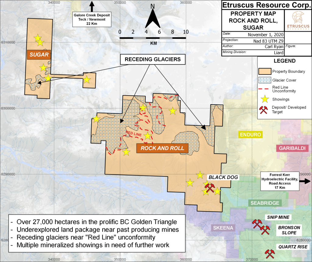
29,344 hectares
Ownership
100% Owned
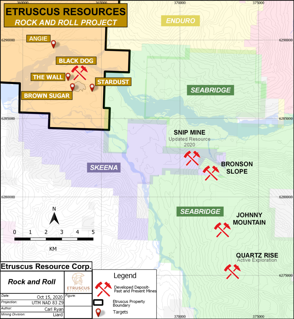
Acquisition:In 2018, Etruscus purchased a 100% interest in the Rock & Roll Property (4723 hectares), originally staked in 1988 on behalf of the Prime Resources Group. After completing an updated 43-101 on the Black Dog Deposit, Etruscus proceeded to quadruple the land package and expanded exploration efforts beyond the resource.
Highlights:
- Ideally located in the Golden Triangle, proximal to multiple historic mines
- Inferred mineral resource on Black Dog VMS Deposit
- Expanded mineralized horizon to over 2.7 Kms (4X previous strike length)
- 1275 line Km’s of VTEM airborne geophysics flown in 2020
- Multiple untested geophysical targets identified
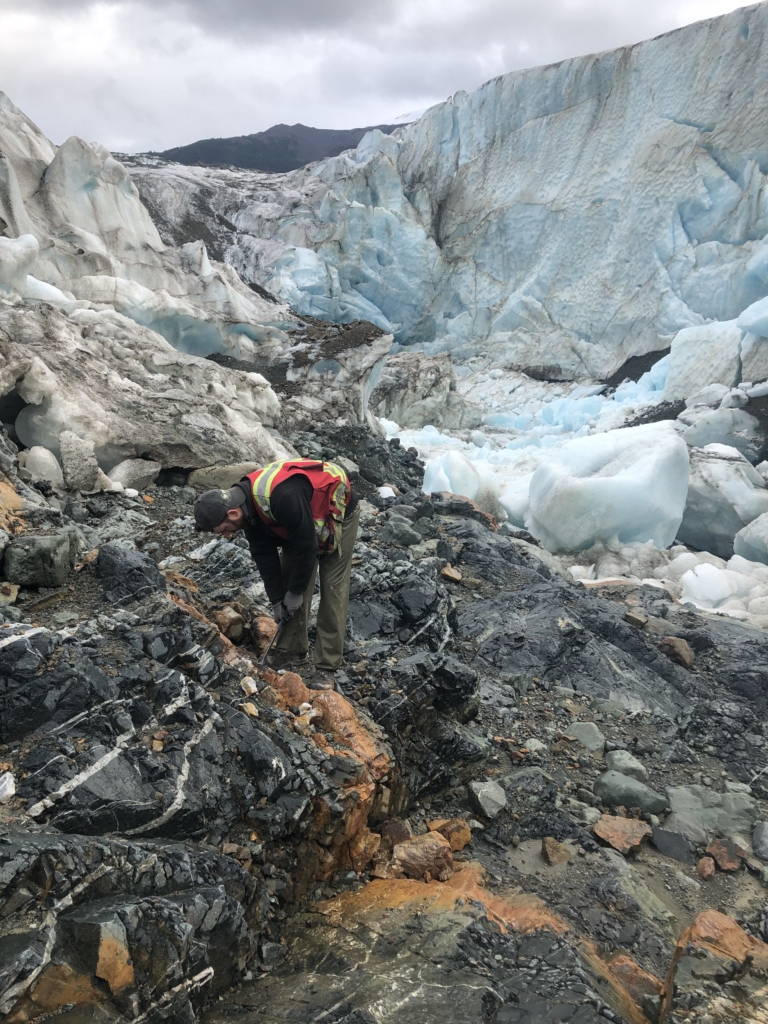
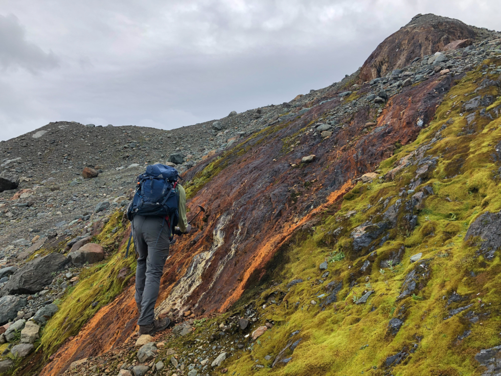
- Large, underexplored land package with significant glacial retreat
- New targets emerging from high grade sampling at the edge of glaciers.
- Prospective “Red Line” stratigraphy mapped across the property
- Potential for multiple ore deposit types; epithermal, porphyry VMS, magmatic sulphides.
Moving Forward: VTEM Flown in 2020has highlighted multiple untested targets on the extended claimsand rock sampling has identified multiple high-gradesilver and gold samples within the vicinity. Significant field programs will be executed this upcoming summer to follow up on emerging targets. Rock sampling, mapping and diamond drilling will be used to expand the knowledge base. Focus on the Black Dog deposit will depend on assay results but will likely include follow on the 2019 and 2020 drilling.
In August, 2018 a NI 43-101 compliant inferred resource at Rock and Roll was produced and estimates the resource to be: 2.02Mt of 2.63 g/t AuEq composed of 0.71 g/t Au, 87.1 g/t Ag, 0.23% Cu, 0.23% Pb and 0.98% Zn.
Location and Access
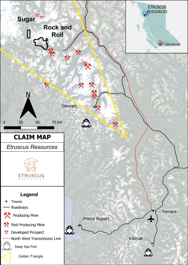
Golden Triangle
The Golden Triangle region of northwestern British Columbia is one of the most richly mineralized areas in the world. With over 219 million ounces of gold in total endowment, two currently operating mines and multiple robust deposits, it is easily one of the most exciting places be exploring for untapped potential. It has also only seen a fraction of the drilling that has occurred in other well know gold camps such as the Abitibi gold belt or the carlin trend, leaving lots of room for future discoveries.
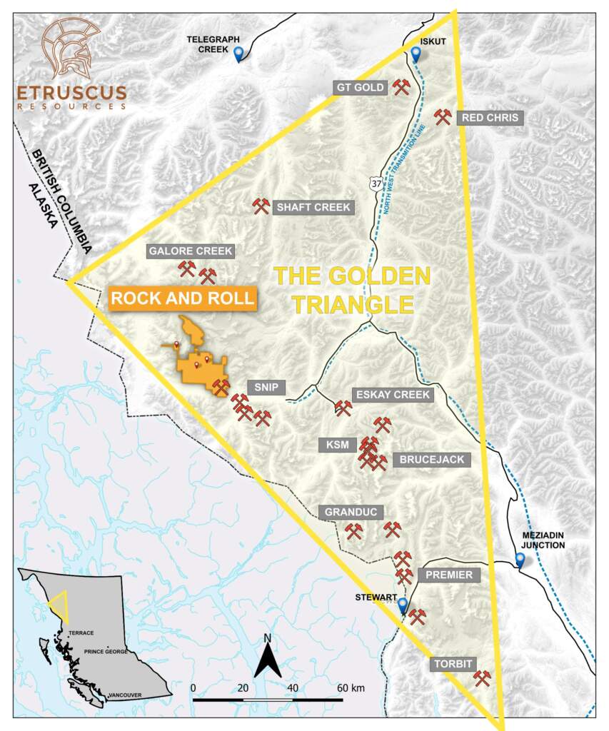
Another major advantage of the Golden Traingle is that it is also very well endowed in silver, copper, lead, zinc and other metals. Aside from hosting porphyry deposits with some of the largest undeveloped copper and gold reserves in the world, the region also hosts a variety of other deposit types. For example, Eskay Creek, a volcanogenic massive sulphide (VMS) deposit, produced 3 million ounces of gold and 160 million ounces of silver from ore with a spectacular grade of 49 g/t gold and 2,406 g/t silver. That deposit was so rich that Barrick transported the untreated ore to a smelter in the United States.
*in total endowment, including inferred resources, as quoted from digigeodata/goldentriangle
Infrastructure
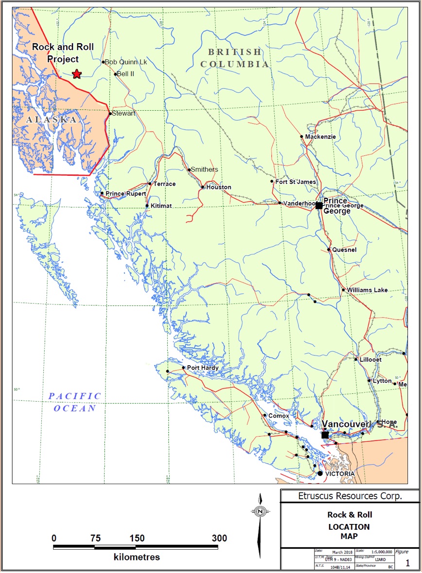
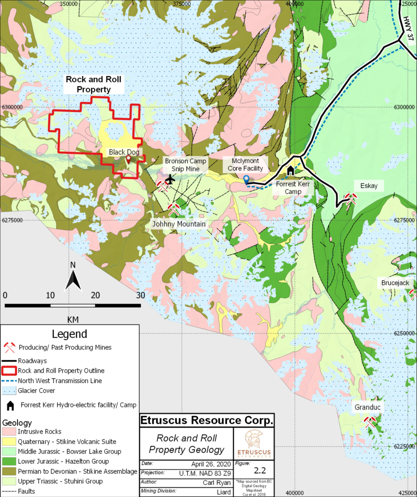
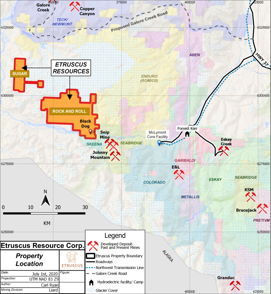
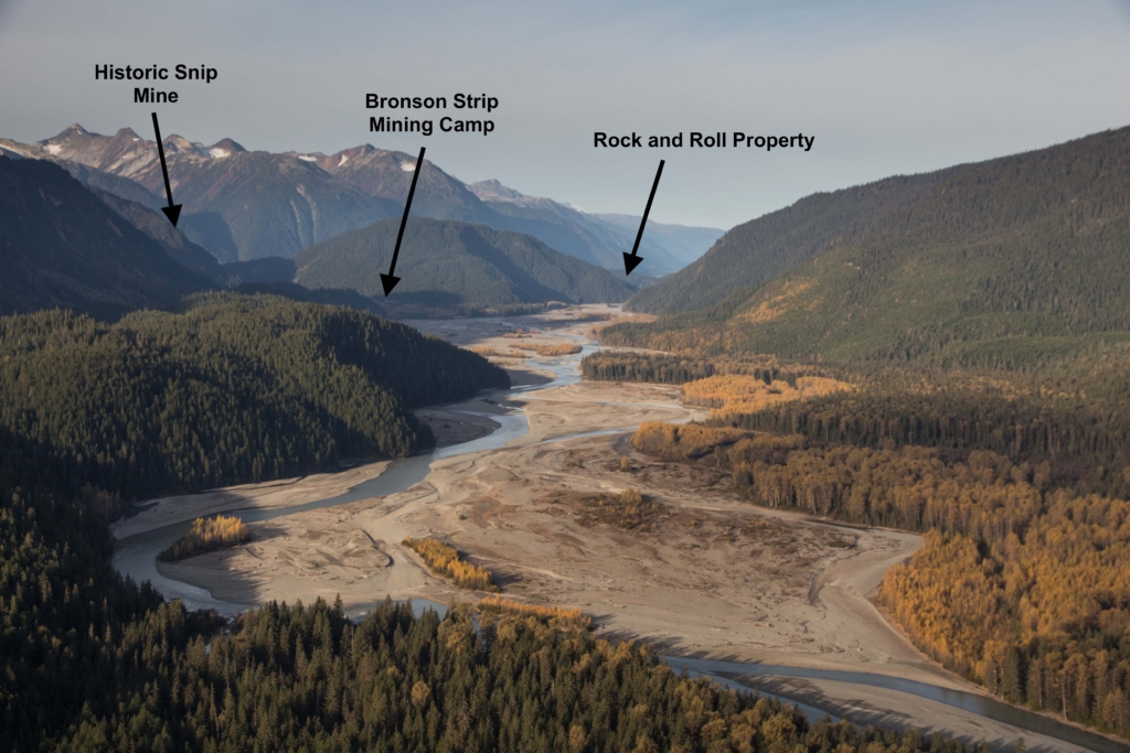
Etruscus’ wholly-owned Rock and Roll Property covers 29,344 hectares in the Iskut River Valley of northwestern British Columbia, 150 Km north of the ocean port at Stewart. The Property is situated within the Golden Triangle which has produced enormous precious and base metal wealth over the past century. This area also contains billions of dollars of undeveloped gold, silver, and copper.
Once seen as remote, British Columbia’s Golden Triangle has recently opened up dramatically, with two mines now in production, three new hydro-power facilities, a link to the provincial power grid and roads throughout the region. World-class deposits can finally be tapped because of infrastructure developments including:
- Completion of a $700 million high-voltage Northwest Transmission Line to the Golden Triangle, which runs 335 km from Terrace to Bob Quinn Lake, and north to the Red Chris mine. The power line to the region was critical in terms of project economics, bringing in electricity that is near the lowest cost in the world.
Access
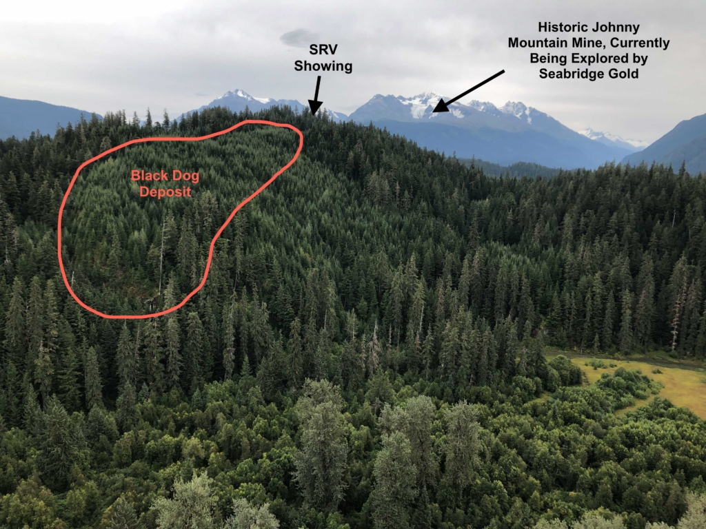
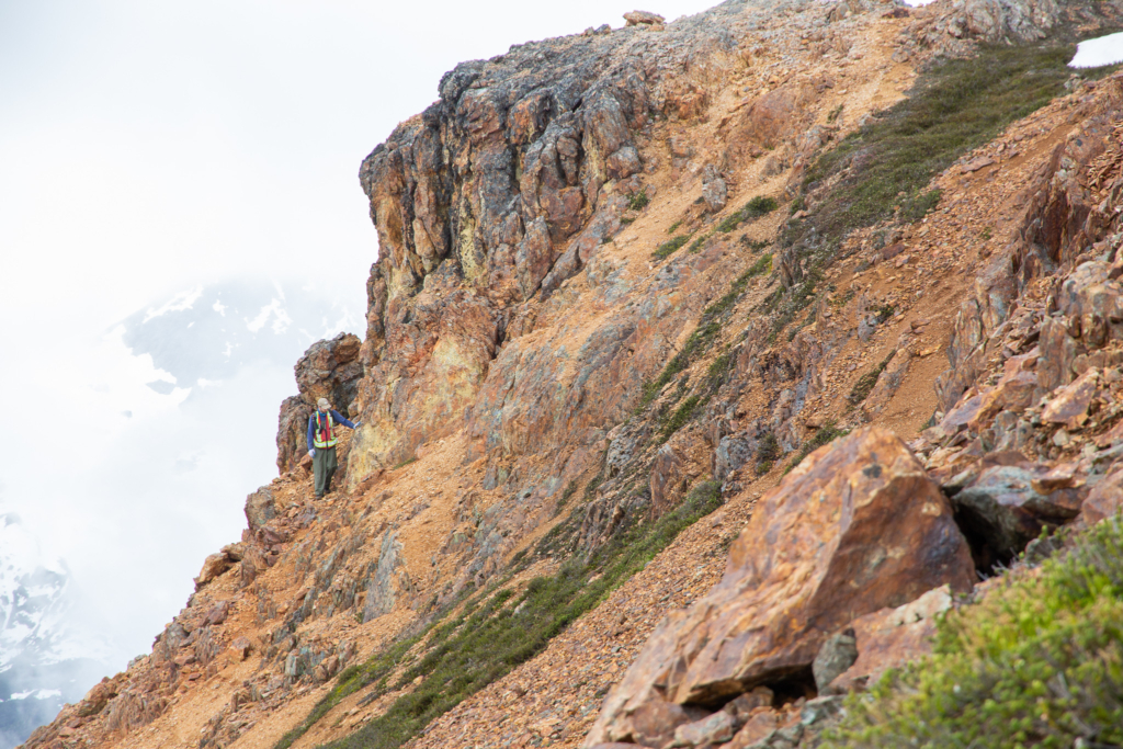
The Rock and Roll Property covers 40 contiguous MTO claims located in the Iskut River Valley and stretching up to the glaciated peaks of Surprise Mountain. Near the Black Dog Deposit, the topography is relatively gentle with forested terrain at an elevation of around 100 meters. This area seem much less snow than the surrounding peaks allowing earlier access onto the property. The rest of the property is located to the north of the Iskut River, is higher in elevation and is dominated with glaciated peaks and alpine terrain.
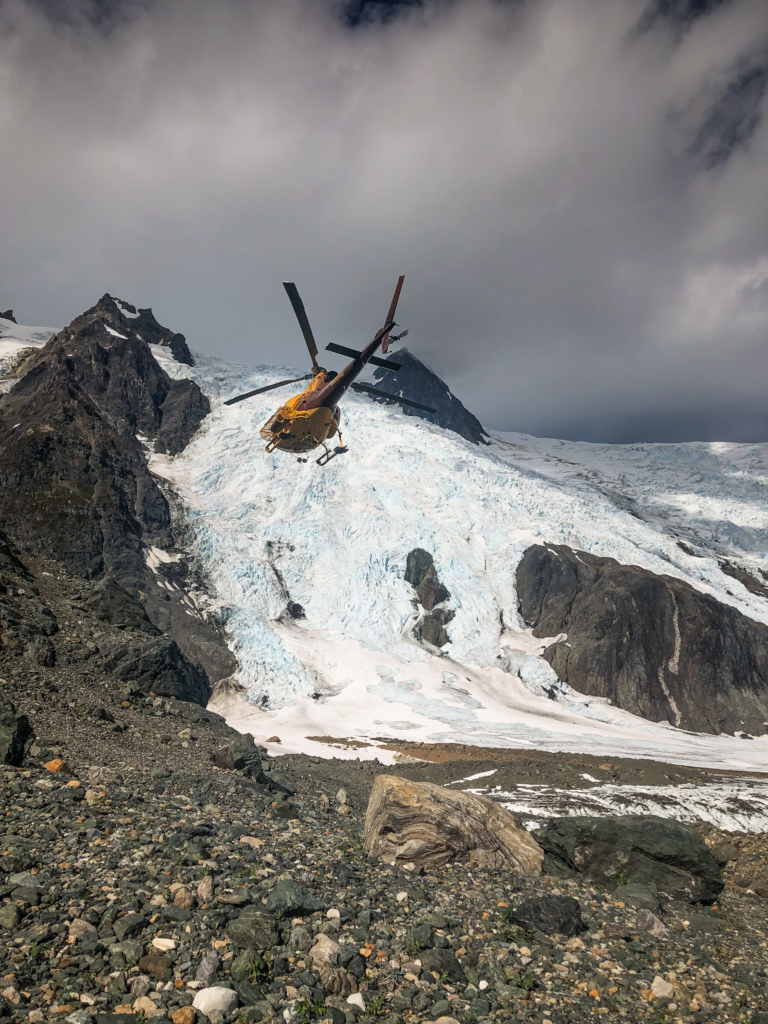
Access to the property is via helicopter from the Forest Kerr hydroelectric facility road 24 kms away. As of 2020, there has been a proposal by Seabridge Gold Corp. to put in a road to the Bronson Camp located 7 km away from the Rock and Roll property. The Bronson Camp is used by Skeena Resources in their exploration of the historic Snip mine as well as by Seabridge Gold in exploration of their Iskut property that contains the historic Johnny Mountain mine. The close proximity of this mining camp will allow the company to get to the Rock & Roll Property faster and at a lower cost to help with future deposit economics as well as improve exploration expenditures.
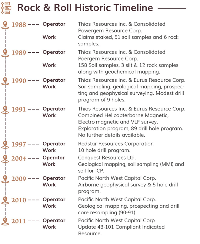
Historical Work
The Rock & Roll area has been explored intermittently since the late 1800’s by placer gold miners either en-route or leaving the Klondike gold fields near Dawson, Yukon. The property was originally staked in 1988 on behalf of the Prime Resources Group-one of Murray Pezim’s companies.
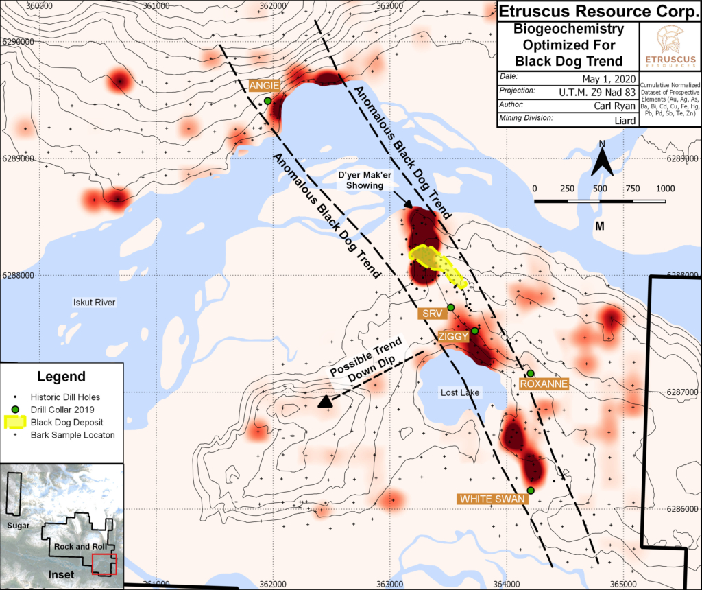
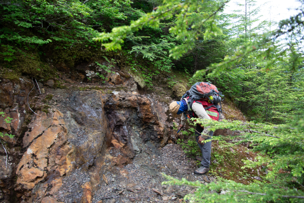
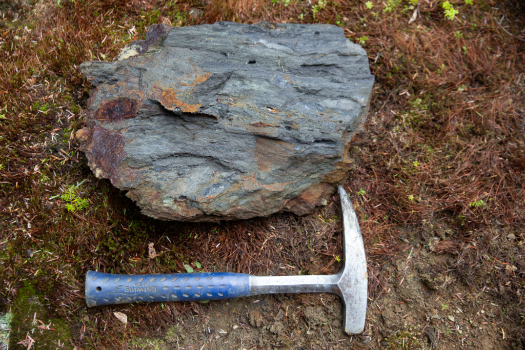
In 1990, exploration (line cutting, geochemical soil sampling, mapping, prospecting, ground geophysical surveys and trenching) led to the discovery of polymetallic, silver-gold-zinc-lead-copper massive sulphide mineralization that became known as the Black Dog Zone.
Notably, the surface expression of the Black Dog Zone is readily apparent in the geochemical soil sample and ground geophysical data.
In the period immediately following the discovery of the Black Dog Showing, Prime drilled 94 holes, totalling 11,063.2 metres in length, in the Black Dog and SRV zone area.
Subsequently, 20 holes totaling 3321.6 meters were drilled by several junior companies-mainly to expand the known mineralized zones. No work has been done on the property since it was returned the Vendors in 2009.
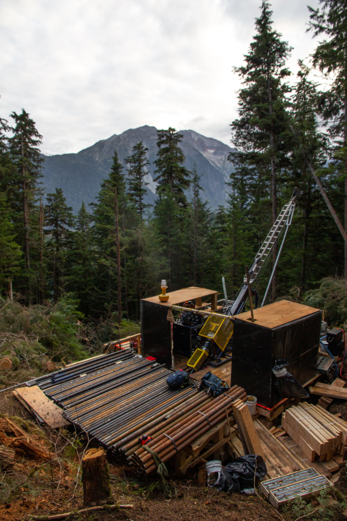
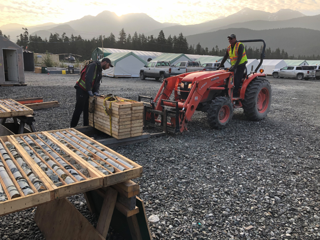
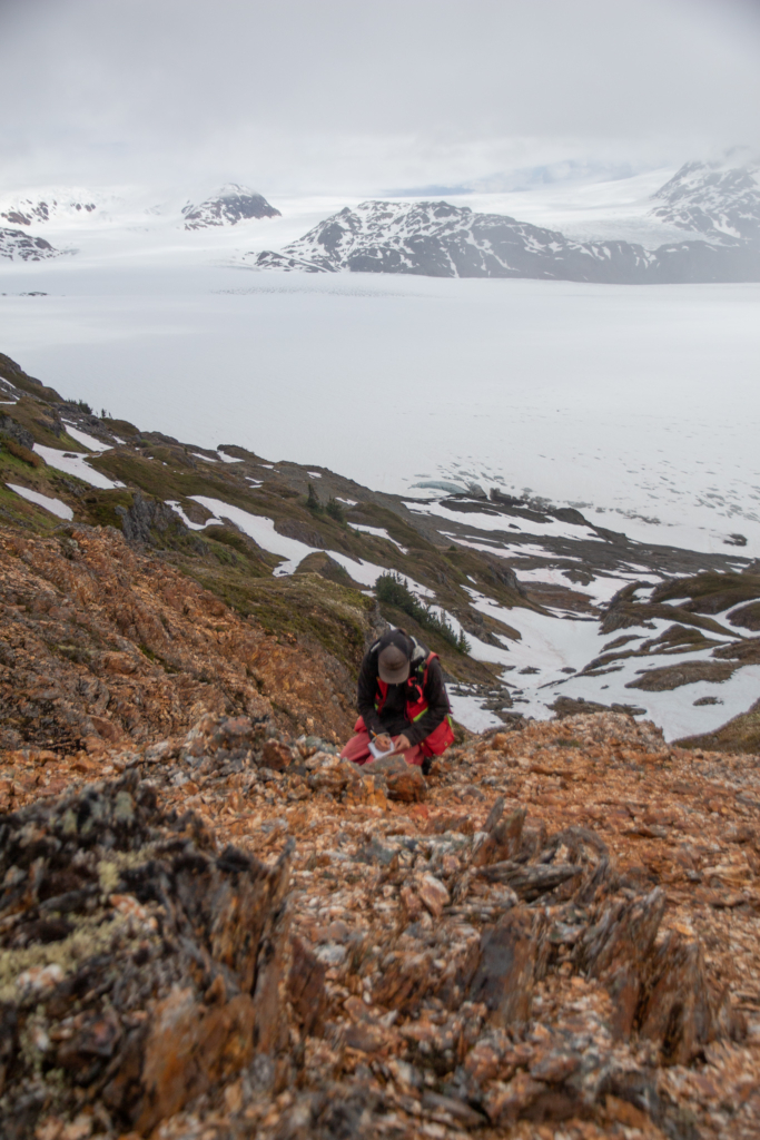
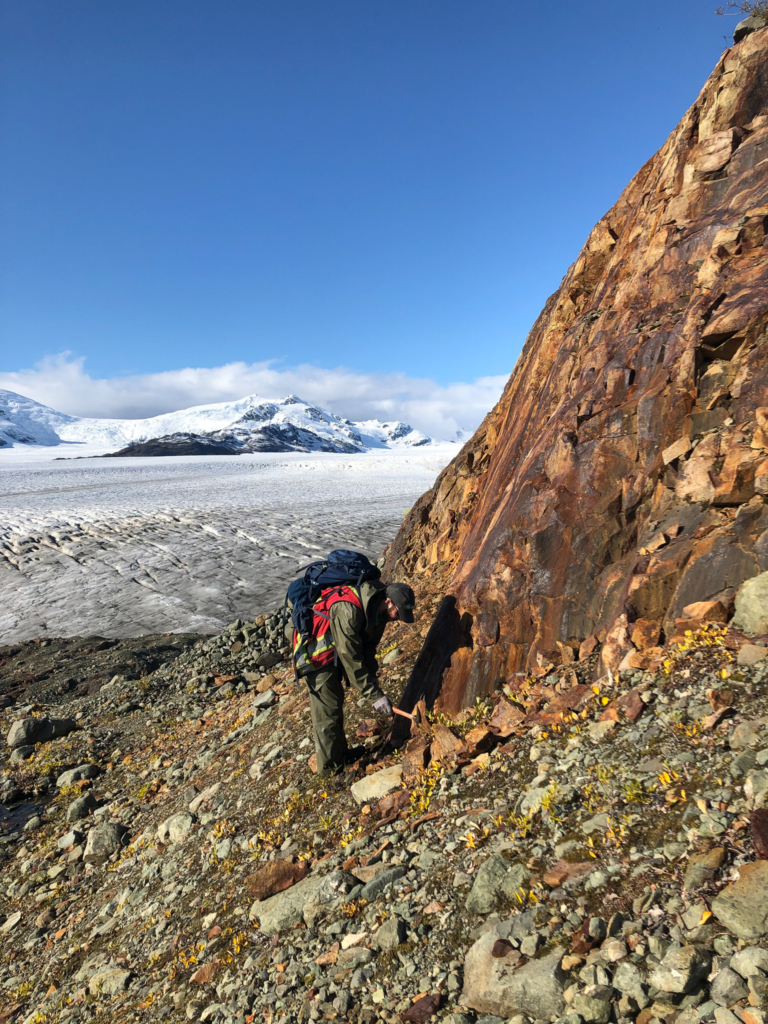
In 2018 Etruscus purchased the property and updated the inferred resource on the Black Dog Deposit. Following acquisition, the property was expanded by 4 times to explore on a regional scale for more VMS potential. Large scale tree bark and rock sampling programs have taken place and updated VTEM was flown in 2020 across a large portion of the Property. Approximately 5000 meters of diamond drilling has also been completed over the two field programs.
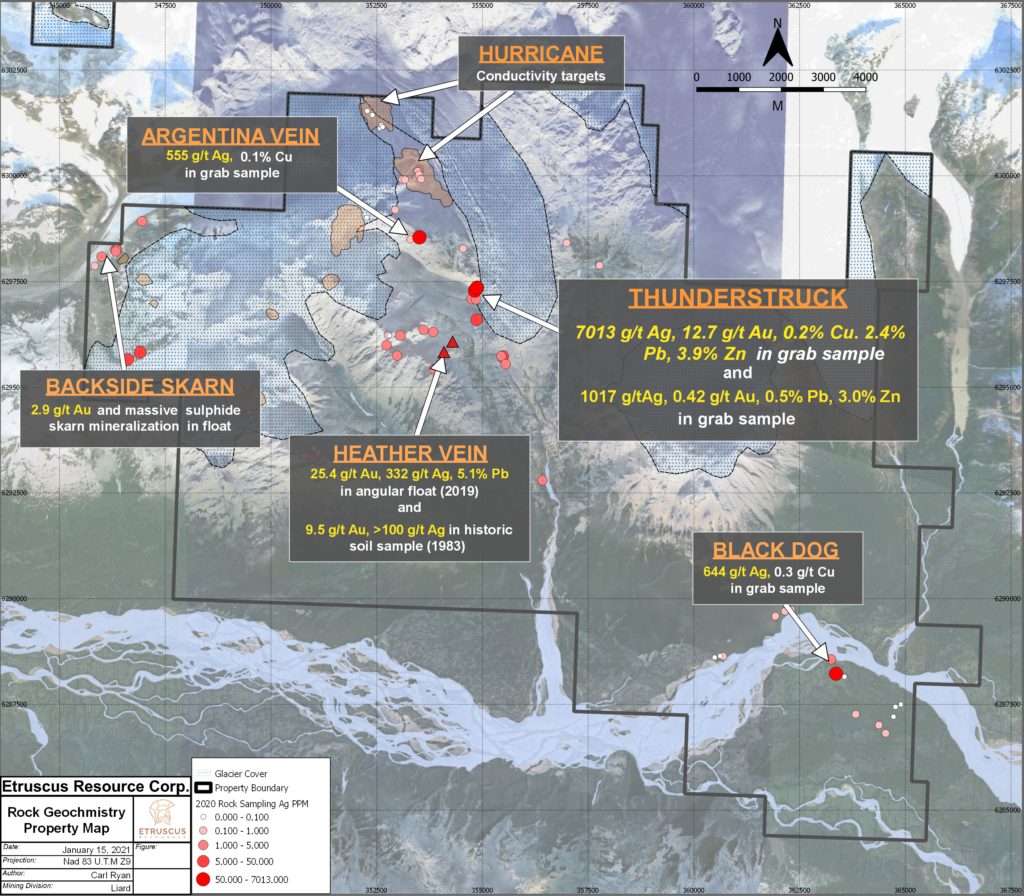
Zappa Target
In 2022 Etruscus Resources completed an expanded 10.5 line km IP Survey over the the Discovery Showing. Results from the IP have confirmed a significant chargeability anomaly now known as Zappa. The Zappa anomaly sits directly below and to the east of the newly mapped surface area and remains open in all directions.
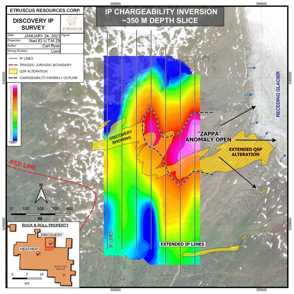
Figure 1 – Plan View Map of Discovery IP Survey Displaying Chargeability Results and Zappa Anomaly
Inversion and 3D modelling of the IP chargeability and resistivity data has identified three highly chargeable zones below the mapped QSP alteration. Two shallow (~75 m below surface) anomalies below the Discovery Showing and a third much larger body (Zappa) is open to depth (>400 m below surface) and is expanding eastward to the margins of the survey. The 600 m wide Zappa chargeability anomaly comes to surface directly below the recently mapped QSP alteration zone and represents a potential heat source for the surface alteration. The geological team has modelled Zappa and believes it demonstrates characteristics and shape of an intrusion that has caused the alteration above.
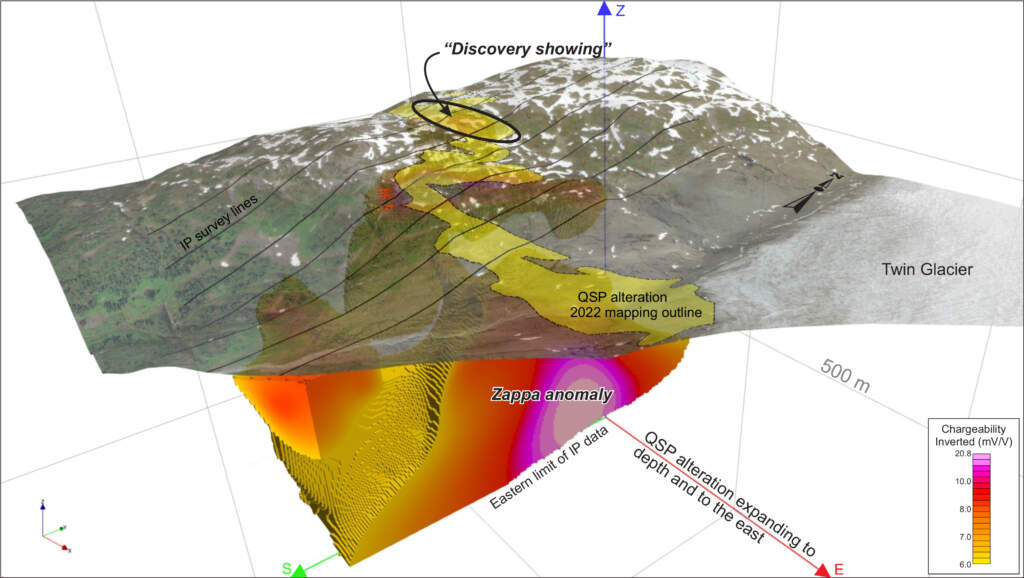
Figure 2 – 3D Model of Chargeability Data from 2022 Discovery Showing IP Survey
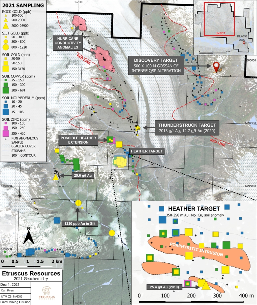
Heather
In 2022, Etruscus completed 3.75 line km of IP over the Heather target area. The Survey grid was completed over an extensive soil anomaly. Focussed rock sampling also also taken place at a newly identified polymetallic quartz-carbonate vein zone containing chalcopyrite, sphalerite and galena. Additionally, a total of 71 soil samples were collected to further extend the 300 m by 350 m copper-gold-molybdenum anomaly identified in the 2021 season.
All rock and soil samples have now been submitted to ALS labs and will be released once available.
Black Dog
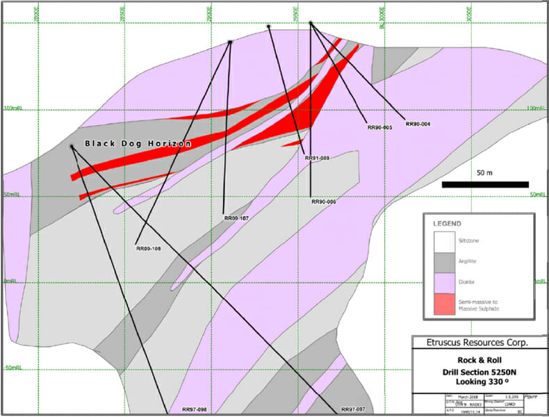
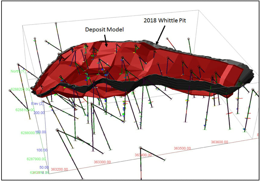
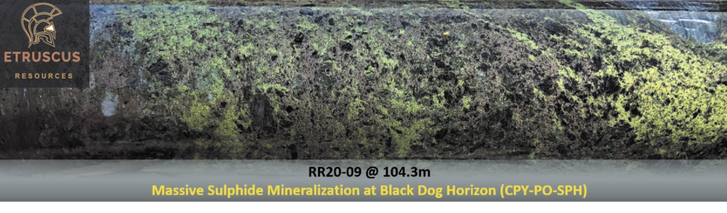
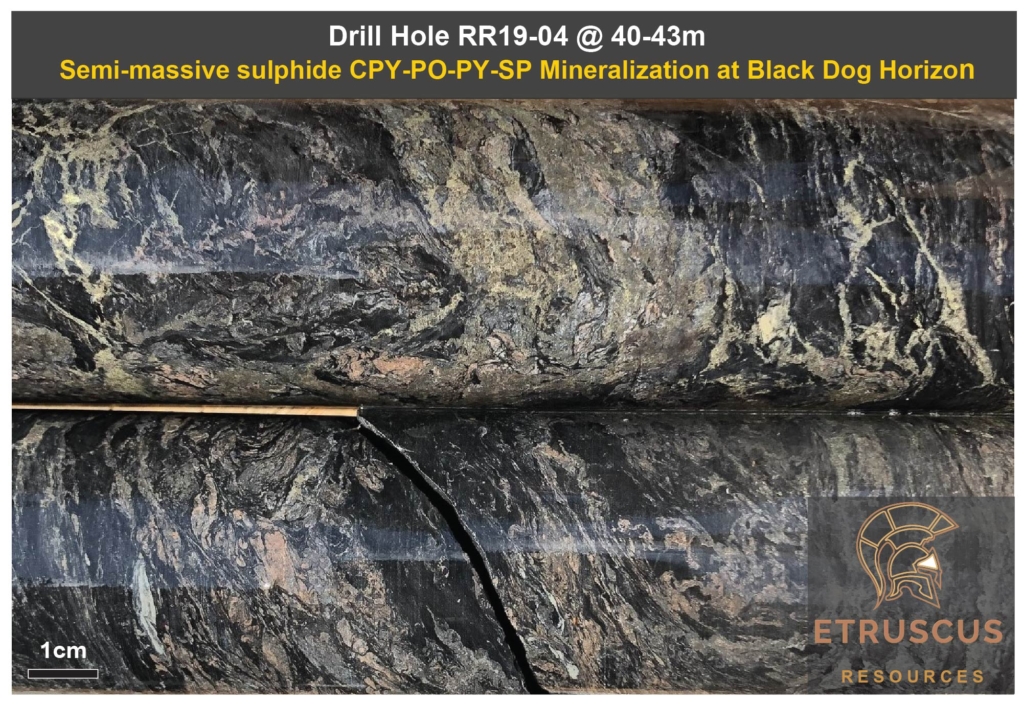
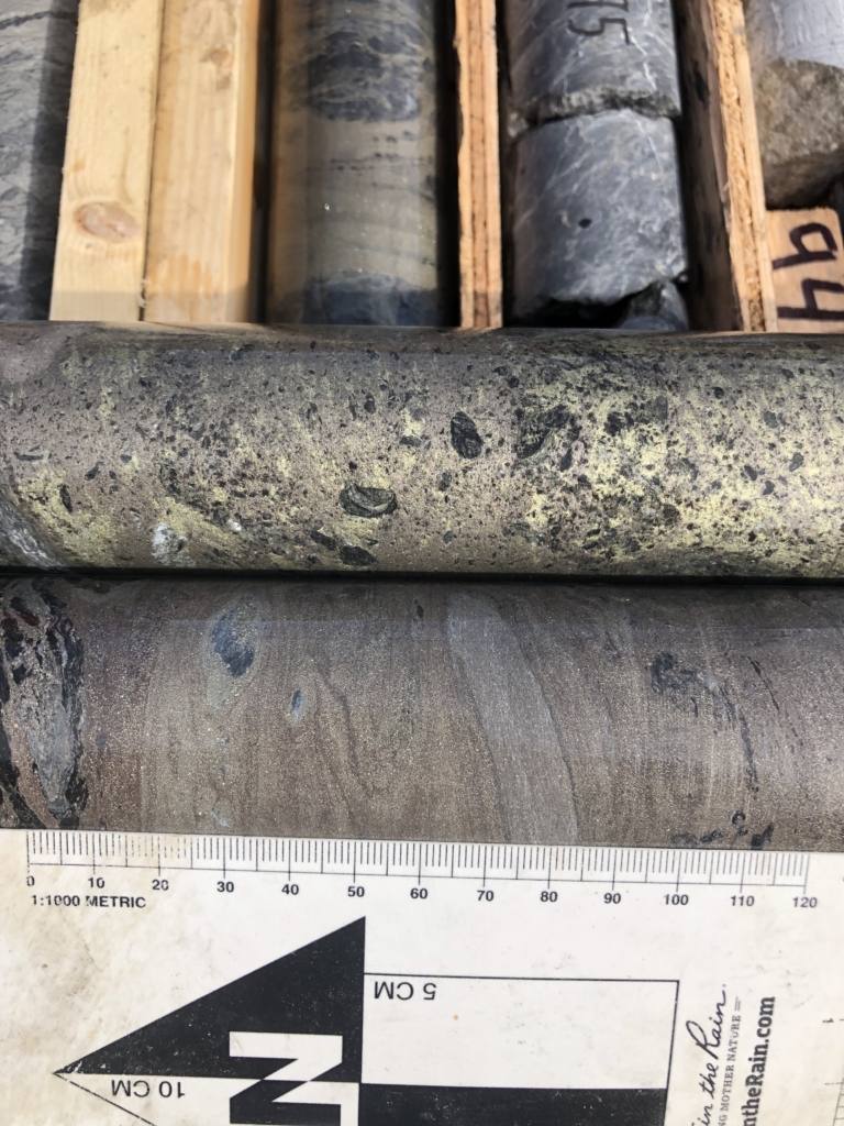
The Black Dog deposit consists of a 1-10m thick horizon of stratiform VMS (Volcanogenic Massive Sulphide) mineralization. The 150 by 650m shallow plunging deposit is located within 100 meters of surface which makes for easy drilling and improved economics. The mineralization contains gold and silver as the dominant metals of interest along with copper lead and zinc. Since VMS systems are known to form in cluster Etruscus Resources has been systematically drilling large step out holes along the prospective horizon in an attempt to discover additional lenses.
Mineralization

RR91-037, 70-73 meter depth (3.02g/t Au, 260.1 g/t Ag, 5.91% Zn, 0.56%Pb, 1.13%Cu)
The basin shaped “Enhanced Precious Metal VMS Deposit” (EPM-VMS) at Black Dog consists primarily of pyrrhotite, pyrite, chalcopyrite and sphalerite. It is stratabound within a layer of exhalites and laminated mudstones. There are two styles of mineralization associated with the Black Dog zone. Massive pyrrhotite with blebs and lenses of chalcopyrite and sphalerite forms the matrix to clasts of predominantly argillite with minor quartz, gypsum and diorite clasts mixed in locally. As well, massive pyrite-sphalerite forms finely laminated lenses locally, with minor pyrrhotite, galena and chalcopyrite. The Black Dog zone extends up to 650 metres to the southeast of the surface showing and similar mineralization occurs in at least three other horizons (or fold repeats) in the section. Diorite disrupts the mineralization and also hosts disseminated pyrrhotite-chalcopyrite mineralization along the length of the deposit. The geophysical features indicate that the Black Dog stratigraphy continues northward to the other side of the Iskut River.
Rock and Roll Inferred Mineral Resource Estimate, August 3rd 2018
(Cut-off Grade 0.5 g/t AuEq) A. Armitage.
| Resource | Grade | AuEq (g/t) | |||||
|---|---|---|---|---|---|---|---|
| Inferred | 2,015,000 Tonnes | Au (g/t) | Ag (g/t) | Cu (%) | Pb (%) | Zn (%) | |
| 0.71 | 87.1 | 0.23 | 0.23 | 0.98 | 2.63 | ||
| Contained Metal | 46,000 Ozs | 5,643,000 Ozs | 10,246,000 Lbs | 10,180,000 Lbs | 43,503,000 Lbs | 170,000 Ozs | |
- Fixed specific gravity value of 3.07 was used to estimate the tonnage from block model volumes.
- Mineral resources are reported at a base case cut-off grade of 0.5 g/t AuEq considering metal prices of $1,250.00/oz Au, $17.00/oz Ag, $3.00/lb Cu, $1.00/lbPb and $1.20/lb Zn, and assuming metal recoveries of 95% for zinc, 80% for lead, 90% for copper, 85% for silver and 80% for gold or 85% for AuEq. Metalurgical recoveries will be adjusted with future metallurgical testing. AuEq = (Au g/t * 0.8) + (Ag g/t * 0.012) + (Cu% * 1.48) + (Pb% * 0.44) + (Zn% * 0.63).
- Mineral resources which are not mineral reserves do not have demonstrated economic viability. All figures are rounded to reflect the relative accuracy of the estimate.
Work Completed
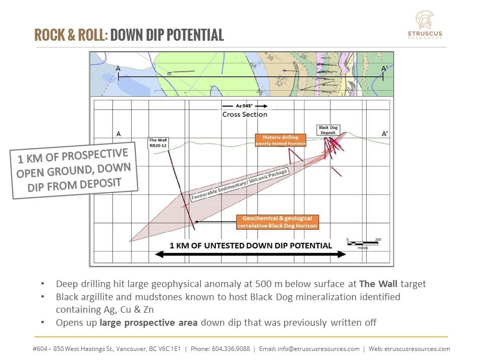
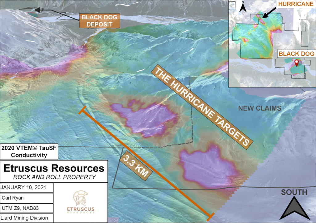
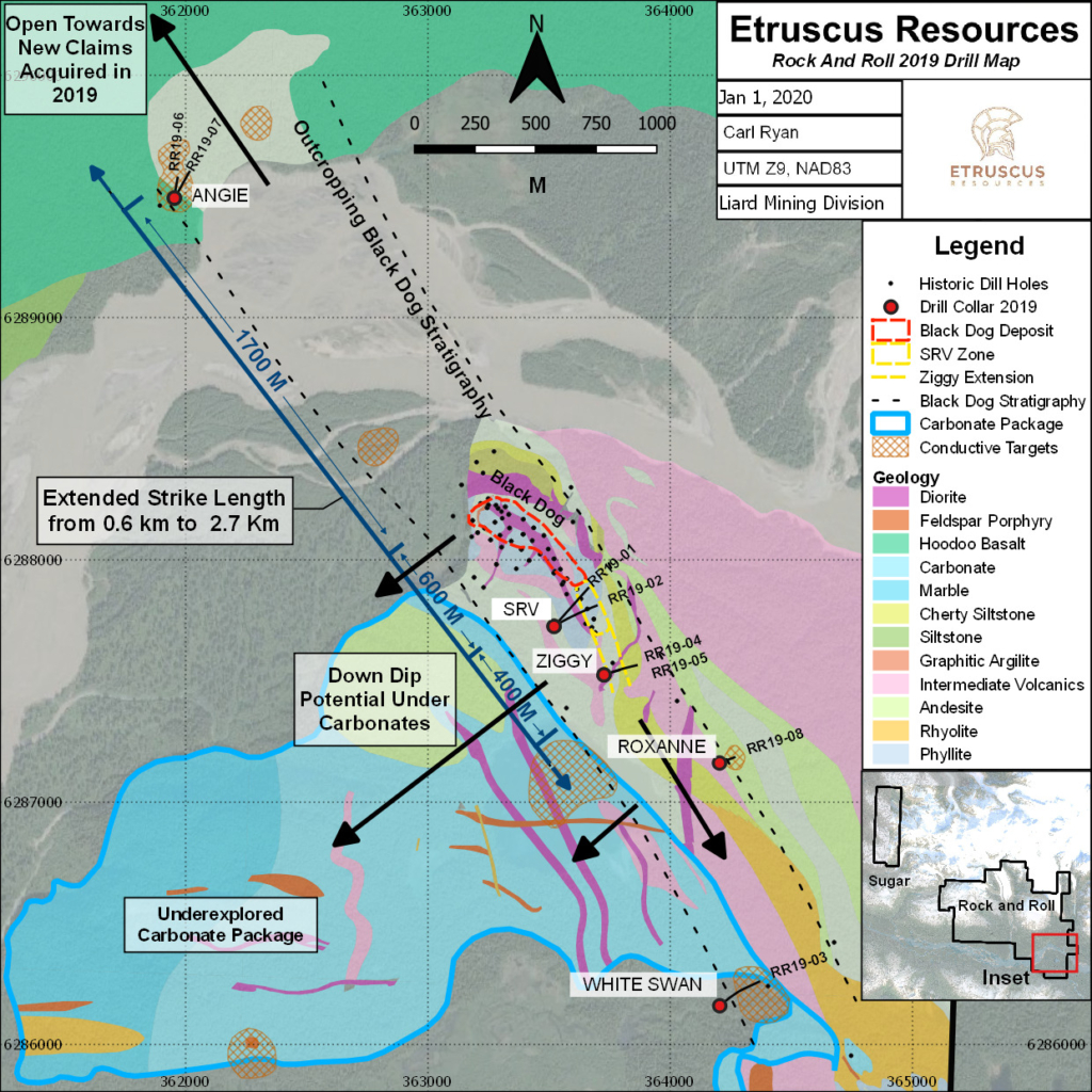
In 2019 Etruscus Resources was able to expand the mineralized horizon up to 2.7 kms with indications of massive sulphide mineralization to the north at the Angie Target as well as continuous mineralization discovered at the Ziggy target to the south.
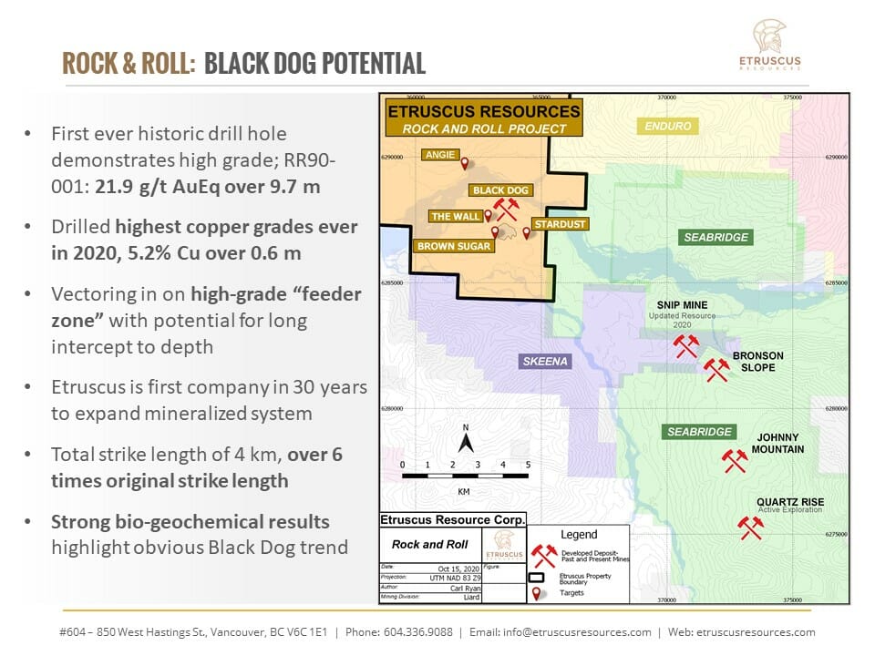
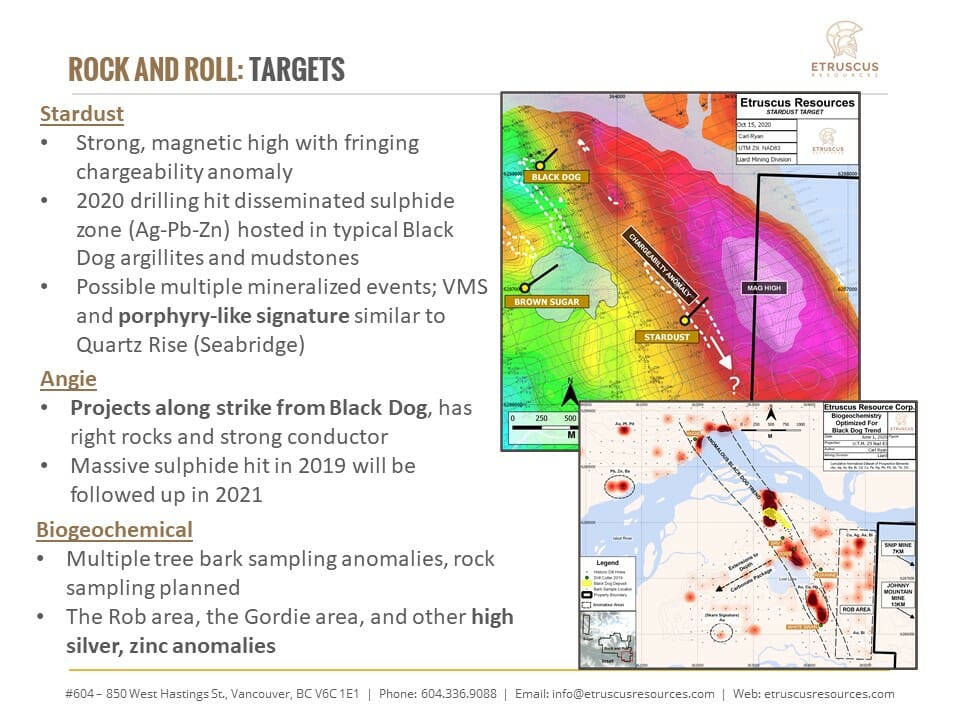
In 2020 targeting was mostly focused on down dip potential at The Wall and The Brown Sugar Targets with large geophysical conductors being tested at depth. These conductors located at 200 and 300 meters depth represent very large potential for further mineralization to exist on the favourable horizon to the south west.
Also drilling completed at the Stardust Target was centered on a magnetic high fringed by a chargeability anomaly. These two characteristics when combined with strong biogeochemistry (tree bark) anomalies, demonstrated a bulls eye target for porphyry potential on the property. The Stardust Target is similar in characteristics to the drilling that was being completed at Seabridge Golds Iskut project.
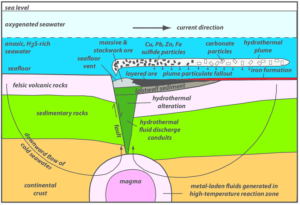
Volcanogenic Massive Sulfide Model
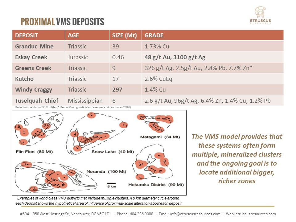
The Rock and Roll Property belongs in the volcanogenic massive sulphide (VMS) class of ore deposits. They are an important resource in British Columbia both for base and precious metals. Current exploration interest is focused largely on the precious metal-rich Eskay-type deposits which are attractive because of their polymetallic nature and bonanza grades (e.g. Eskay Creek – 1998 reserves 1,356,240t at 2684 g/t Ag, 58 g/t Au).
Volcanogenic massive sulfide (VMS) ore deposits are a type of metal sulfide ore deposit, mainly copper-zinc, which are associated with and created by volcanic-associated hydrothermal events in submarine environments. They occur within environments dominated by volcanic or volcanic rocks, and the deposits are coeval and coincident with the formation of said volcanic rocks. As a class, they represent a significant source of the world’s copper, zinc, lead, gold and silver ores,with cobalt, tin, barium, sulfur, selenium, manganese, cadmium, indium, bismuth, tellurium, gallium and germanium as co- or by-products.
The VMS ore deposits typically comprise one or more thin sheets of massive to well layered pyrite, sphalerite, galena and chalcopyrite commonly within felsic volcanic rocks and interlayered, terrigenous clastic rocks with calcalkaline basaltic to andesitic tuffs and flows. The lenses may be zoned, with a Cu-rich base and a Pb-Zn-rich top; low-grade stockwork zones commonly underlie lenses and barite or chert layers may overlie them.
A hundred years of exploitation from 16 major VMS mines in BC has produced nearly 109,000,000 t of ore. This has resulted in the production of over 3,000,000 kg Ag, 82,500 kg Au, 1,460,000 t Cu, 96,400 t Pb, 1,000,000 t Zn and 2,000 t Cd. The bulk of this production has come from five mines – Britannia, Anyox (Hidden Creek), Myra Falls and Granduc, and Eskay Creek. Tulsequah Chief has received mine certification. Their average deposit size is 1.5 Mt containing 1.3% Cu, 1.9 % Pb, 2.0 % Zn, 0.16 g/t Au and 13 g/T Ag. British Columbia deposits range from less than 1 to 2 Mt to more than 10 Mt. In British Columbia, most deposits are Cambrian, Late Triassic and, less commonly, Mississippian-Permian in age. They are highly variable in size. B.C. deposits range in size from less than 1 Mt to more than 113 Mt.
Volcanogenic Massive Sulfide Deposit Examples
(Examples of each deposit are presented solely for comparative purposes and are not intended to characterize
the mineralization at the Rock and Roll Property)
Windy Craggy has reserves in excess of 113.0 Mt containing 1.9 % Cu, 3.9 g/t Ag and 0.08% Co.
Britannia: Between 1905 and 1977, the Britannia orebodies yielded approximately 47.8 million tonnes of ore grading 1.1% copper, 0.65 % zinc, 6.8 grams per tonne silver and 0.6 grams per tonne gold.
Myra Falls: The overall pre-mining mineral resource (all categories) was 40 M tonnes grading 2.1 g/t Au, 49.0 g/t Ag, 1.8% Cu, 0.5% Pb, and 6.1% Zn
Granduc reported reserves before production of 39,316,435 tonnes grading 1.73 per cent copper
Goldstream has a total resource (reserves and production) of 1.8 Mt containing 4.81 % Cu, 3.08 % Zn and 20.6 g/t Ag and
Kutcho Creek: Probable Mineral Reserve (2017 estimate) of 10.4 Mt @ 2.01% Cu, 3.19% Zn, 34.61 g/t Ag and 0.37 g/t Au
Tulsequah Chief: An NI 43-101 compliant probable mineral reserve estimate is given at 6,447,098 tonnes grading 1.13 per cent copper, 1.04 per cent lead, 5.59 per cent zinc, 2.30 grams per tonne gold and 81 grams per tonne silver
Geology
The Rock and Roll Property is located on the western margin of the Stikine Island-arc Terraneadjacent to the Coast Plutonic Intrusive Belt. Both Paleozoic and Mesozoic sedimentary and volcanic rocks make up a large portion of the Property area. These rocks have been intruded by Triassic intrusive porphyritic dykes as well as felsic Tertiary plutons of the Coast Mountain Complex. Within the Property the stratigraphy has been assigned to the Paleozoic Stikine Assemblage as well as the Mesozoic Stuhini Group rocks (Massey,2005). On the northern portion of the Property, Cenozoic mafic volcanic flows erupted from Hoodoo Mountain have resulted in large portions of the area being covered.
Local geology in this area consists of interlayered intermediate volcanic and argillite-siltstone units. The volcanic rocks are generally massive and fine to medium grained with no significant primary structures preserved. The argillite is commonly carbonaceous and contains rare, thin, pyritic lamina. Argillite-siltstone units are thinly bedded, grey to black, locally siliceous, and very deformed, commonly making identification of S0 or S1 difficult to impossible. Rare greywacke beds were tentatively identified. In general, the rocks are weakly to strongly iron carbonate altered with quartz-calcite and calcite stringers throughout. The volcanic and sedimentary rocks are also intruded by felsic dykes locally.
These Paleozoic and Mesozoic sedimentary and volcanic rocks are cut by intrusions of various ages. A series of north-south striking diorite dykes outcrop across the Property. These rocks are medium-grained and moderately strained. Within the mineralized stratigraphy around the Black Dog horizon, diorite is very common and is generally strongly sheared and brecciated with dark colouration due to contamination/remobilization of carbonaceous material. There are abundant feldspar crystals in the groundmass of this unit, occurring as laths and weakly glomeroporphyritic clusters. This diorite forms abundant narrow, strongly deformed and altered intervals within the sedimentary rocks, especially noticeable in proximity to the mineralized horizons.
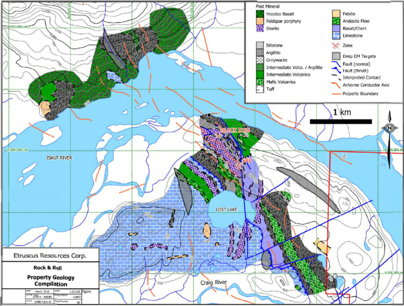
Rock and Roll Property Geology

2024 Plans
Etruscus Resources plans to execute a field program during the 2024 season. A strong focus will be set on developing the Heather and the Discovery Targets. The program will include an expanded induced-polarization survey focused on testing the 500m to the east of the Discovery target with hopes of identifying drill targets for a future program.
Results from the 2024 program will be released once available.